Meet the marine infrastructure that helps keep Ireland safe and tracks our changing seas
Each month, an expert from the Marine Institute will shine a light on their area of work, sharing insights on our ocean knowledge. As the national agency responsible for supporting the sustainable development of our marine resources, the Marine Institute delivers scientific knowledge, expert advice and services to government, industry and a wide range of stakeholders.
This month, Tomasz Dabrowski and Guy Westbrook, Ocean, Climate and Information Services, write about the Marine Institute’s marine infrastructure, ocean observations and modelling.
Meet the marine infrastructure that helps keep Ireland safe and tracks our changing seas
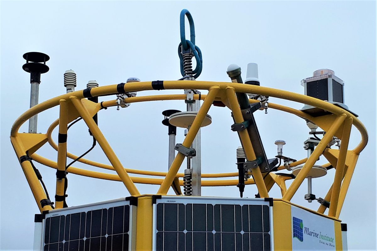
Every time you glance at your phone's weather app to decide whether to grab a jacket or leave the umbrella at home, you're benefiting from a system most people have no idea exists. Around the clock, marine research infrastructures are measuring the very heartbeat of our marine weather and transmitting that data back to shore from the various sites around the island, every hour of every day.
When Storm Éowyn tore across the Atlantic, many of us remember the roar of the wind and days without power. Perhaps, fewer people recall that the storm's arrival was no surprise. Met Eireann, Ireland's Meteorological agency, forecasted Éowyn long before it reached land, while the Irish M-buoy network, managed by the Marine Institute, collected and relayed a full suite of met data, including atmospheric pressure through the hurricane, charting and recording its full intensity as it hit.
Damage from extreme weather events is hard to reduce in real time - houses and infrastructure can't be moved in a matter of days. But the relatively low casualty numbers in the wake of such storms tell their own story: accurate, early forecasting saves lives.
Under the remit of the Department of Agriculture, Food and the Marine (DAFM), the Marine Institute manages Ireland's marine research infrastructure network and supplies data to Met Éireann, a line agency of the Department of Housing, Local Government and Heritage (DHLGH). Together they do far more than tell us whether to pack a waterproof. The data feeds shipping bulletins, gale and swell warnings, oceanographic monitoring, climate research, and international modelling programmes. In the longer-term these data describe Ireland’s wind and wave environment - crucial information when determining the appropriate location of offshore renewable energy developments. It is, in every sense, critical national infrastructure that delivers.
All of the data are openly and freely publicly accessible in real time through the international scientific data server called Environmental Research Division Data Access Program (ERDDAP), where hourly readings, trends, and monitoring locations are updated continuously and available for anyone to download in real time or after weather events.
While storms make headlines, marine heatwaves and plankton shifts largely do not. Yet the latest ocean science and observations suggest they are both changing in ways that matter.
Marine heatwaves are periods when the ocean remains unusually warm for days or even weeks at a time. Marine Institute scientists are recording significant increases in both the frequency and intensity of these events in Irish waters, set against a background of steady year-round warming, particularly across Ireland's shelf seas.
At the same time, shifts are being observed in phytoplankton communities - the tiny marine plant-like organisms at the base of marine food chains. The abundance of some phytoplankton species has increased throughout the year, signalling broader changes in the marine environment. Both events need close monitoring as they can potentially disrupt ecosystems by stressing marine animals having knock on effects through marine food webs.
Researchers at the Marine Institute build, maintain and upgrade predictive models to anticipate both phenomena, a task that demands exactly the kind of long-term, high-quality observational data that only a permanent monitoring network can supply.
Current ocean monitoring and observation systems can predict waves, storm surges, and sea level changes several days ahead with considerable accuracy. But gaps remain, particularly along Ireland's rugged coastline, where narrow straits, offshore islands, and intricate harbour geometries can challenge models that perform effectively in open water, mainly due to a poor understanding of the physical characteristics of the ocean floor. Ireland is well positioned for the next leap, thanks to the INFOMAR programme's high-resolution seabed mapping filling in these gaps, one of the most comprehensive bathymetric datasets in the world. Combining this with future iterations of the already very advanced high-resolution numerical ocean models, downscaling further into the coast, opens the door to forecasting conditions in an ever-increasing number of bays and inshore waters with greater precision.
While the Marine Institute’s ocean forecasting is already state-of-the-art, the next breakthrough, scientists say, is coming from integrating ocean and atmosphere models into a coupled system. Traditionally, most models treat the atmosphere as a one-way driver of ocean conditions. But the physical exchange runs both ways: sea surface temperature influences air pressure, which shapes the atmosphere, which in turn shapes the sea. Fully coupled models, where ocean and atmospheric components mesh continuously, can further improve forecast accuracy. Add the computing power available more readily through AI-enhanced modelling and digital twin approaches, and the picture of Ireland's ocean over the coming decades is set to be increasingly complete.
Ireland is an island nation. Our weather is predominantly shaped by the ocean, our food depends on our ocean’s health, our coastal communities live within reach of its extremes. The marine observation and forecasting system maintained by the Marine Institute, sister agencies and partners right across the North-East Atlantic region is, in the most literal sense, the country's early warning system, one that has already helped protect lives and livelihoods, and will be called on to do far more as the climate continues to change.
So, the next time you check the weather, know that at all points of the compass, a buoy is rolling in the Atlantic swell, quietly gathering the data that made this forecast possible.
This article first appeared in The Marine Times (April 2026).